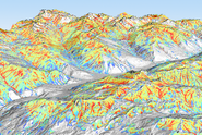
Projects

Des résultats récents le démontrent : l’utilisation de drones permet de déterminer efficacement et économiquement les hauteurs de neige en montagne. Cette technologie ouvre de nouvelles portes à la nivologie.

Comprehensive satellite data, for smaller areas also drone images, with high resolution are well suited for the documentation of avalanche periods. For a (near-) realtime use the SLF is working on automating the mapping.

In this project we develop and combine cutting-edge remote sensing technology with snow depth distribution and RAMMS avalanche modelling. With this we want to improve the decision base for road safety in the Dischma valley in Davos.

Informationen über großräumig verteilte Schneehöhen basieren immer noch hauptsächlich auf interpolierten Punktmessungen. Neue Entwicklungen in der Sensor- und Softwaretechnologie für die digitale Photogrammetrie in den letzten zwei Jahrzehnten bieten neue Möglichkeiten, hochauflösende, digitale Oberflächenmodelle (DSM) auch über schneebedeckte hochalpine Regionen abzuleiten.

This project aims at improving the early detection of bark beetle damage in forests in the canton of Grisons as well as the prioritisation of management against bark beetle infestation in protective forests in the long term.

Large scale avalanche hazard indication maps for Graubünden and Liechtenstein.

Publications

Bühler Y., Stoffel A., Liechti D. (2024) Where to put the weather station? Optimizing the location for automated snow depth measurements based on remote sensing, avalanche modeling and terrain characteristics. In K. Gisnås, P. Gauer, H. Dahle, M. Eckerstorfer, A. Mannberg, & K. Müller (Eds.), Proceedings of the international Snow Science Workshop 2024. Oslo: Norwegian Geotechnical Institute. 1054-1060. Institutional Repository DORA

Manconi A., Bühler Y., Stoffel A., Gaume J., Zhang Q., Tolpekin V. (2024) Brief communication: monitoring impending slope failure with very high-resolution spaceborne synthetic aperture radar. Nat. Hazards Earth Syst. Sci. 24(11), 3833-3839. doi:10.5194/nhess-24-3833-2024 Institutional Repository DORA

Stoffel A., Harvey S., Bühler Y. (2024) On the influence of snow depth on surface shape and roughness in the release areas of observed skier-triggered avalanches. In K. Gisnås, P. Gauer, H. Dahle, M. Eckerstorfer, A. Mannberg, & K. Müller (Eds.), Proceedings of the international snow science workshop 2024. Oslo: Norwegian Geotechnical Institute. 1256-1262. Institutional Repository DORA

Bühler Y., Stoffel A., Eberhard L., Bührle L. (2023) Fotogrammetrische Schneehöhenkartierung aus Drohnen-, Flugzeug­- und Satellitenbildern. In Eidg. Forschungsanstalt für Wald, Schnee und Landschaft, WSL (Ed.), WSL Berichte: Vol. 134. Neue Fernerkundungs­technologien für die Umweltforschung und Praxis. Birmensdorf: Eidg. Forschungsanstalt für Wald, Schnee und Landschaft, WSL. 61-66. doi:10.55419/wsl:33072 Institutional Repository DORA

Bührle L.J., Marty M., Eberhard L.A., Stoffel A., Hafner E.D., Bühler Y. (2023) Spatially continuous snow depth mapping by aeroplane photogrammetry for annual peak of winter from 2017 to 2021 in open areas. Cryosphere. 17(8), 3383-3408. doi:10.5194/tc-17-3383-2023 Institutional Repository DORA

Ringenbach A., Bebi P., Bartelt P., Rigling A., Christen M., Bühler Y., … Caviezel A. (2023) Shape still matters: rockfall interactions with trees and deadwood in a mountain forest uncover a new facet of rock shape dependency. Earth Surf. Dyn. 11(4), 779-801. doi:10.5194/esurf-11-779-2023 Institutional Repository DORA

Schmucki G.R., Bartelt P., Bühler Y., Caviezel A., Graf C., Marty M., … Huggel C. (2023) Photogrammetrically UAV based terrain data generation and automatic extraction of torrential properties. In M. Pirulli, A. Leonardi, & F. Vagnon (Eds.), E3S web of conferences: Vol. 415. 8th international conference on debris flow hazard mitigation (DFHM8). Les Ulis Cedex A: EDP Sciences. 03026 (5 pp.). doi:10.1051/e3sconf/202341503026 Institutional Repository DORA

Schmucki G., Bartelt P., Bühler Y., Caviezel A., Graf C., Marty M., … Huggel C. (2023) Towards an automated acquisition and parametrization of debris‐flow prone torrent channel properties based on photogrammetric‐derived uncrewed aerial vehicle data. Earth Surf. Process. Landf. 48(9), 1742-1764. doi:10.1002/esp.5585 Institutional Repository DORA

Bühler Y., Bebi P., Christen M., Margreth S., Stoffel L., Stoffel A., … Bartelt P. (2022) Automated avalanche hazard indication mapping on a statewide scale. Nat. Hazards Earth Syst. Sci. 22(6), 1825-1843. doi:10.5194/nhess-22-1825-2022 Institutional Repository DORA

Bühler Y., Bebi P., Christen M., Margreth S., Stoffel A., Stoffel L., … Kühne R. (2022) Automatisch berechnete Gefahrenhinweiskarten für Lawinen. Automated avalanche hazard indication mapping. Wildbach- Lawinenverbau. 86(190), 88-95. Institutional Repository DORA

Ringenbach A., Stihl E., Bühler Y., Bebi P., Bartelt P., Rigling A., … Caviezel A. (2022) Full-scale experiments to examine the role of deadwood in rockfall dynamics in forests. Nat. Hazards Earth Syst. Sci. 22(7), 2433-2443. doi:10.5194/nhess-22-2433-2022 Institutional Repository DORA

Ringenbach A., Bebi P., Bartelt P., Rigling A., Christen M., Bühler Y., … Caviezel A. (2022) Modeling deadwood for rockfall mitigation assessments in windthrow areas. Earth Surf. Dyn. 10(6), 1303-1319. doi:10.5194/esurf-10-1303-2022 Institutional Repository DORA

Bühler Y., Bührle L., Eberhard L., Marty M., Stoffel A. (2021) Grossflächige Schneehöhen-Kartierung mit Flugzeug und Satellit. Geomat. Schweiz. 119(9-10), 212-215. Institutional Repository DORA

Caviezel A., Ringenbach A., Demmel S.E., Dinneen C.E., Krebs N., Bühler Y., … Bartelt P. (2021) The relevance of rock shape over mass - implications for rockfall hazard assessments. Nat. Commun. 12, 5546 (9 pp.). doi:10.1038/s41467-021-25794-y Institutional Repository DORA

Eberhard L.A., Sirguey P., Miller A., Marty M., Schindler K., Stoffel A., Bühler Y. (2021) Intercomparison of photogrammetric platforms for spatially continuous snow depth mapping. Cryosphere. 15(1), 69-94. doi:10.5194/tc-15-69-2021 Institutional Repository DORA

Schweizer J., Mitterer C., Techel F., Stoffel A., Reuter B. (2020) On the relation between avalanche occurrence and avalanche danger level. Cryosphere. 14(2), 737-750. doi:10.5194/tc-14-737-2020 Institutional Repository DORA

Eker R., Bühler Y., Schlögl S., Stoffel A., Aydın A. (2019) Monitoring of snow cover ablation using very high spatial resolution remote sensing datasets. Remote Sens. 11(6), 699 (20 pp.). doi:10.3390/rs11060699 Institutional Repository DORA

Noetzli C., Bühler Y., Lorenzi D., Stoffel A., Rohrer M. (2019) Schneedecke als Wasserspeicher. Drohnen können helfen, die Abschätzungen der Schneereserven zu verbessern. Wasser Energ. Luft. 111(3), 153-157. Institutional Repository DORA

Bühler Y., von Rickenbach D., Stoffel A., Margreth S., Stoffel L., Christen M. (2018) Automated snow avalanche release area delineation – validation of existing algorithms and proposition of a new object-based approach for large-scale hazard indication mapping. Nat. Hazards Earth Syst. Sci. 18(12), 3235-3251. doi:10.5194/nhess-18-3235-2018 Institutional Repository DORA

Bühler Y., Stoffel A., Eberhard L., Feuerstein G.C., Lurati D., Guler A., Margreth S. (2018) Drohneneinsatz für die Kartierung der Schneehöhenverteilung. Bündnerwald. 71(8), 20-24. Institutional Repository DORA

Show all
×