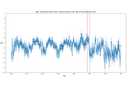
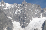
Info

Andrea Manconi is Environmental Engineer (University of Cagliari, Italy) and PhD in Geophysics (University of Potsdam, Germany). His research interests focus on the analysis, interpretation of surface deformation due to natural hazards in mountain areas. To this end, he develops and applies remote sensing approaches, in particular by using space borne radar datasets, as well as ground-based monitoring sensors. He holds the Habilitation “Venia Legendi” in Engineering Geology and Geophysics at the Swiss Federal Institute of Technology, ETH Zurich, Department of Earth Sciences.

Projects

In this project, funded by the Swiss Agency for Development Cooperation (SDC / DEZA), we propose to apply large scale hazard indication mapping algorithms to the Himalayan province of Uttarakhand. Our goal is to identify unstable rock/ice masses and perform thermo-mechanical simulations - at the large-scale - to predict the danger of rock/ice avalanches, such as the recent event in Chamoli.

Fernerkundung kann wertvolle Informationen über die Aktivität von Hanginstabilitäten in Hochgebirgsregionen lieferen.

Fernerkundungsdaten - insbesondere die Optische- und Radarbilder - sind leistungsfähige Instrumente zur Überwachung von Hanginstabilitäten. In diesem Projekt untersuchen wir, wie diese Instrumente das Gefahrenmanagement auf regionaler Ebene unterstützen und unser Verständnis von alpinen Massenbewegungen verbessern können.

Rockfalls, debris flows and rockslides are gravitational mass movements that occur frequently in the mountains. Several SLF research groups are jointly developing methods to detect potential instabilities as early as possible.

Auf der Grundlage von Sentinel-1 SAR-Daten und anhand verschiedener Testgebiete in Europa wird ein System zur Erfassung von Störungen im Wald entwickelt. Mittels Zeitreihenanalyse auf Bestandesniveau sollen die durch Störungen verursachten Veränderungen im Wald in den SAR-Daten erkannt werden.

Homogenous inventories of unstable alpine slopes by exploiting satellite radar interferometry.

With this project proposal we aim at testing a procedure based on high spatial resolution SAR data in Uttarakhand. Our goal is to promptly follow surface changes leading towards potential catastrophic slope failure events.

The project aims at developing, testing and implementing machine learning routines applied to typical geological datasets to automatically identify structural feature traces and surfaces and differentiate discontinuity types.

Test of the suitability of the new SAR satellite ICEYE to monitor accelerations of surface motion at glaciers in critical conditions.

The project MODULATE aims at defining procedures useful for systematic displacement monitoring programs (and potentially early warning systems) involving radar imagery acquired from different sensors and platforms.

Publications

Prakash N., Bickel V.T., Manconi A. (2025) Mapping landslides on earth, moon, and mars using satellite imagery and deep learning techniques. In I. Șandric, V. Ilinca, & Z. Chitu (Eds.), Earth observation applications to landslide mapping, monitoring and modeling. Cutting-edge approaches with artificial intelligence, aerial and satellite imagery. Amsterdam: Elsevier. 147-169. doi:10.1016/B978-0-12-823868-4.00008-8 Institutional Repository DORA

Prakash N., Manconi A., Mondini A.C. (2025) Rapid mapping of landslides using satellite SAR imagery: a progressive learning approach. Appl. Comput. Geosci. 25, 100224 (12 pp.). doi:10.1016/j.acags.2025.100224 Institutional Repository DORA

Manconi A., Bühler Y., Stoffel A., Gaume J., Zhang Q., Tolpekin V. (2024) Brief communication: monitoring impending slope failure with very high-resolution spaceborne synthetic aperture radar. Nat. Hazards Earth Syst. Sci. 24(11), 3833-3839. doi:10.5194/nhess-24-3833-2024 Institutional Repository DORA

Manconi A., Jones N., Loew S., Strozzi T., Caduff R., Wegmueller U. (2024) Monitoring surface deformation with spaceborne radar interferometry in landslide complexes: insights from the Brienz/Brinzauls slope instability, Swiss Alps. Landslides. 21, 2519-2533. doi:10.1007/s10346-024-02291-z Institutional Repository DORA

Munch J., Bühler Y., Zhuang Y., Manconi A., Bartelt P. (2024) Understanding flow transitions in multi-component avalanches. In J. Schneider (Ed.), Interpraevent 2024. Conference proceedings. Klagenfurt: Interpraevent. 138-143. Institutional Repository DORA

Pedrelli R., Bottero A., Manconi A. (2024) Bäume als Sensoren zur Überwachung von Rutschungen nutzen. Bündnerwald. 77(1), 18-21. Institutional Repository DORA

Dasser G., Munch J., Bühler Y., Bartelt P., Manconi A. (2023) Applied space-borne remote sensing to identify mass movements and the exemplary modelling of potentially catastrophic failures in the Bhagirathi Area, India. In T. P. Kersten & N. Tilly (Eds.), Publikationen der Deutschen Gesellschaft für Photogrammetrie, Fernerkundung und Geoinformation e.V.: Vol. 31. 43. wissenschaftlich-technische Jahrestagung der DGPF in München. Jahrestagung der DGPF. Photogrammetrie, Fernerkundung, Geoinformation. Stuttgart: Deutsche Gesellschaft für Photogrammetrie, Fernerkundung und Geoinformation (DGPF). 276-287. Institutional Repository DORA

Manconi A. (2023) Untersuchungen von Massenbewegungen mit satelliten­basierter Radarinterferometrie: Möglichkeiten und Grenzen. In Eidg. Forschungsanstalt für Wald, Schnee und Landschaft, WSL (Ed.), WSL Berichte: Vol. 134. Neue Fernerkundungs­technologien für die Umweltforschung und Praxis. Birmensdorf: Eidg. Forschungsanstalt für Wald, Schnee und Landschaft, WSL. 39-42. doi:10.55419/wsl:33064 Institutional Repository DORA

Marchetti G., Manconi A., Comiti F. (2023) Limitations in the use of Sentinel-1 data for morphological change detection in rivers. Int. J. Remote Sens. 44(21), 6642-6669. doi:10.1080/01431161.2023.2274317 Institutional Repository DORA

Andreadis S., Gialampoukidis I., Manconi A., Cordeiro D., Conde V., Sagona M., … Kompatsiaris I. (2022) Earthquakes: from Twitter detection to EO data processing. IEEE Geosci. Remote Sens. Lett. 19, 3511005 (5 pp.). doi:10.1109/LGRS.2022.3149541 Institutional Repository DORA

Bickel V.T., Manconi A. (2022) Decadal surface changes and displacements in Switzerland. J. Geovis. Spat. Anal. 6, 24 (9 pp.). doi:10.1007/s41651-022-00119-9 Institutional Repository DORA

Jones N., Manconi A., Löw S. (2022) Satellitenfernerkundung der räumlichen und zeitlichen Entwicklung der Oberflächendeformationen. Schweiz. Z. Forstwes. 173(3), 118-123. doi:10.3188/szf.2022.0118 Institutional Repository DORA

Manconi A., Mondini A.C., AlpArray working group (2022) Landslides caught on seismic networks and satellite radars. Nat. Hazards Earth Syst. Sci. 22(5), 1655-1664. doi:10.5194/nhess-22-1655-2022 Institutional Repository DORA

Strozzi T., Caduff R., Jones N., Manconi A., Wegmüller U. (2022) L-Band StripMap-ScanSAR persistent scatterer interferometry in alpine environments with ALOS-2 PALSAR-2. In IEEE international symposium on geoscience and remote sensing (IGARSS). IGARSS 2022 - 2022 IEEE international geoscience and remote sensing symposium. Proceedings. Danvers: IEEE. 1644-1647. doi:10.1109/IGARSS46834.2022.9884743 Institutional Repository DORA

Glueer F., Loew S., Seifert R., Aaron J., Grämiger L., Conzett S., … Manconi A. (2021) Robotic total station monitoring in high alpine paraglacial environments: challenges and solutions from the Great Aletsch Region (Valais, Switzerland). Geosciences. 11(11), 471 (19 pp.). doi:10.3390/geosciences11110471 Institutional Repository DORA

×