Large scale avalanche hazard indication maps
Perry Bartelt
Marc Christen
Stefan Margreth
Andreas Stoffel
Lukas Stoffel
Peter Bebi
Christoph Marty
2018 - 2030
Cooperation- Amt für Wald und Naturgefahren AWN, Graubünden
- Kanton Wallis, Dienststelle für Wald und Landschaft
- Kanton Tessin
- AlpSolut
- University of Alaska Fairbanks
- Alaska Division of Geological & Geophysical Surveys
- Autonome Provinz Trient
- Autonome Provinz Bozen - Südtirol
- University of Otago, Neuseeland
- Ulugh Beg Astronomical Institute (UBAI) Uzbekistan Academy of Sciences
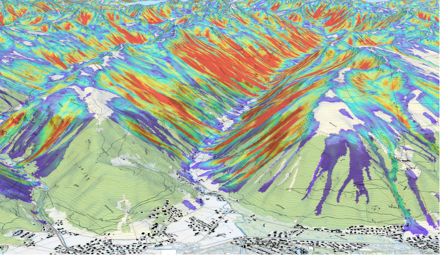
Legally binding hazard maps show where areas are at risk from avalanches. However, creating such maps is time-consuming and is therefore only made for predefined areas. At the SLF, we have developed an automated process that calculates area-wide avalanche hazard indication maps based on the terrain model and information about the forest and snow climatology. Although these are less reliable than hazard maps, they can be calculated over large areas for different scenarios. This is particularly useful in areas where no hazard maps exist or where there are major changes, for example in the forest. In addition, the large-scale effects of changes, for example due to more intense heavy precipitation, can be visualized and compared.

Large Scale Hazard Indication Mapping 
Hazard indication maps are less detailed than hazard maps, but can provide a first large-scale overview of natural hazards based on numerical simulations for large areas. This is particularly useful for regions with sparse event documentation, as is the case in most mountainous regions of the world. High-resolution digital elevation models, which are generated using modern remote sensing methods, are increasingly available for mountainous regions. This makes it possible to carry out meaningful numerical avalanche simulations for entire mountain ranges. In order to be able to carry out dynamic avalanche simulations with the most modern simulation software such as RAMMS, an exact identification of the avalanche areas and heights is required. The SLF developed an algorithm to identify potential avalanche areas based on terrain parameters. The algorithm was validated using a reference data set for three areas in the Davos region (Bühler et al. 2018) and has now been applied to the entire canton of Graubünden (Bühler et al. 2022). Now we are doing these calculations for the canton of Valais and the canton of Ticino.
Calculating different scenarios 
Once the release areas have been identified and the corresponding release depths calculated, a simulation with friction parameters that have proven themselves in hazard mapping is carried out for each release polygon. The procedure can be carried out for different scenarios, for example with a 5-30 year (frequent) or 100-300 year (extreme) return period. This enables efficient, automated execution of dynamic avalanche simulations, not only for individual avalanche tracks, but also for large-scale applications at regional to national level.
In several projects with partners such as the canton of Graubünden, the Alaska Division of Geological & Geophysical Surveys or the autonomous province of Trentino in Italy, this approach is used to create large-scale hazard maps that, for example, allow the protective function of forests to be assessed against snow avalanches. For the maps showing the avalanche terrain in White Risk, the researchers simulated more than 860,000 typical skier avalanches. The simulations were combined with terrain classification into a new product for ski tour planning (Harvey et al. 2018). The automated procedure for calculating hazard maps has already been used for individual regions in Uzbekistan, Georgia, Chile and Afghanistan, where there is still no avalanche hazard information. This is of great help when planning new infrastructure and evaluating existing protective measures for villages and roads.
