11.10.2021 | Roman Oester | News SLF
The Swiss Alps and the Jura are home to 186 stations that measure snow depth, temperature and wind speed. Such data are among the most crucial tools for assessing the snow and avalanche situation. Stations are typically erected at new sites when there is a growing need for additional data in a particular region, for instance. However, extensive preparatory work is required before a new measuring station can be installed. This was the case with the search for a new site in Ticino's Vergeletto Valley.
Data from the field are of inestimable value to the avalanche warning service of the SLF when it comes to assessing the snow, avalanche and weather situation. Alongside observations, assessments and modelling, they help ensure that forecasts are as accurate as possible. The automated stations making up the IMIS measuring network (see info box), which are operated by the SLF on behalf of the participating cantons, provide key data to this end.
More data needed in the Vergeletto Valley 
There is very little data available for the Vergeletto Valley, a side valley of the Onsernone Valley. The valley experiences a lot of precipitation and the upper section is prone to potentially massive avalanches, with the worst ones reaching the valley floor. As such, the cantonal and local avalanche services would like to have better data so that they can more accurately estimate the avalanche hazard and therefore better plan the measures needed to protect the local population. Precipitation measurements in this area would be of particular interest to MeteoSwiss as well. Last but not least, the SLF national avalanche warning service would also benefit from the additional data from the Ticino mountains.
Not all sites suitable 
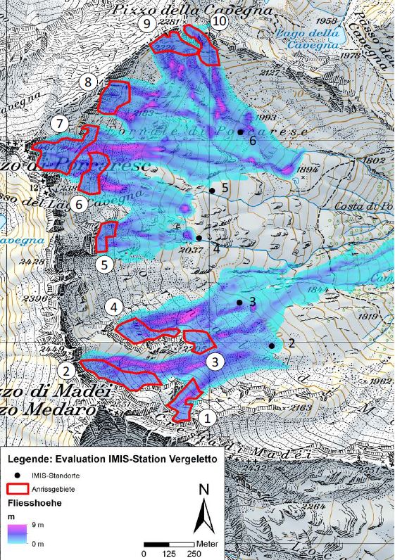
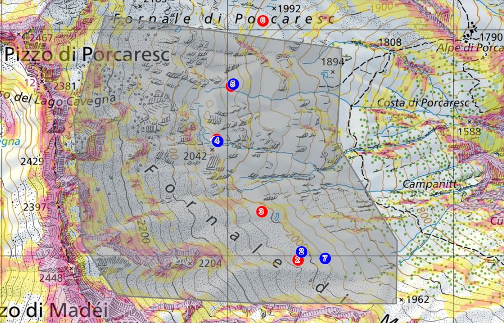
This is why a new IMIS measuring station is now to be installed. However, some preliminary work is required first, because not every site is suitable. At high altitudes, the search for appropriate sites is difficult and expensive. As snow deposits are fundamentally irregular due to the interaction between terrain and wind, snow stations must, if possible, be erected on flat sites that are sheltered from the wind. They must also be safe from avalanches in order to be able to provide representative information on snow cover. Representatives from the Canton of Ticino first selected six potential sites in the Vergeletto Valley on a map. The SLF then assessed the basic suitability of these sites. SLF experts used RAMMS simulation software to analyse the avalanche risk and calculate the fall trajectories, strength and flow heights of potential avalanches. Once the more theoretical work was complete, representatives from the Canton of Ticino and the SLF visited the valley in both summer and winter, which allowed them to examine the topographical conditions and snow cover in the field and incorporate these details into their evaluation.
Using a drone to measure snow depth distribution 
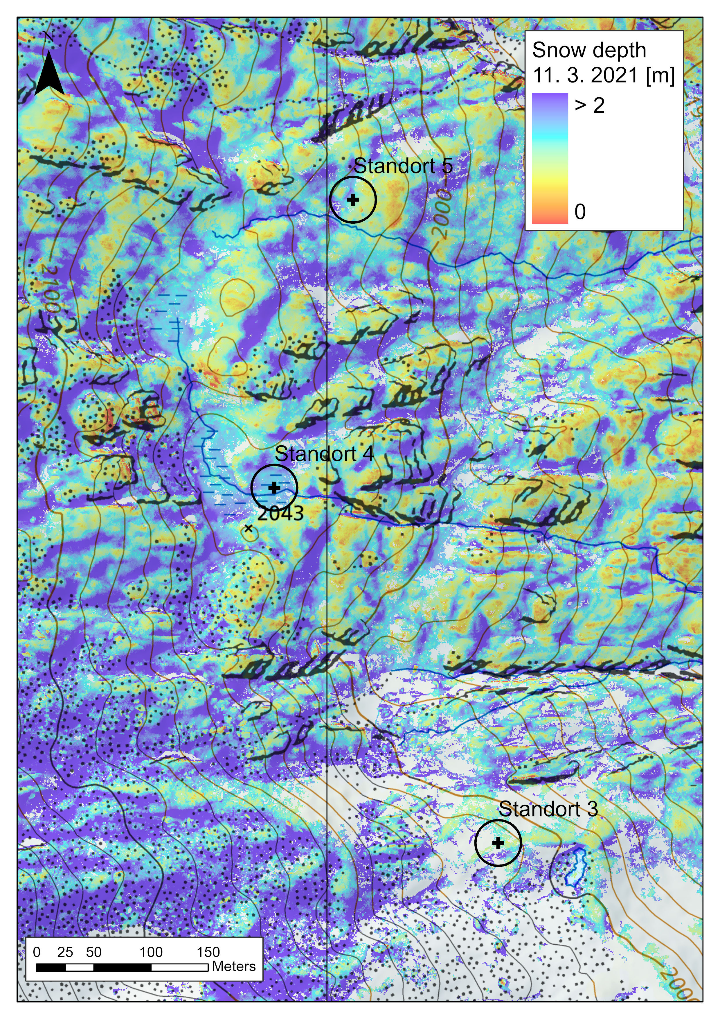
As early as the first survey in summer, it became apparent that some sites were unsuitable or less suitable for a new IMIS station, while the experts had to slightly alter the position of others. During the winter survey, they measured the snow depth both manually and using a drone. Snow depth models were created using photogrammetric data from the drone. These models reproduce the snow depth distribution at the various sites almost to the centimetre. Based on the available information, representatives from the Canton of Ticino finally chose the most suitable location. A test station was erected at this site in summer 2021. During the 2021/22 winter season, this station will collect data on the snow depth curve and other meteorological parameters (air temperature, relative humidity, wind direction and wind speed). Once these data have been evaluated, a decision can then be made as to whether the site is suitable for a permanent IMIS station.


Image 1 of 5
The sites identified during the summer survey are marked in red, while those measured during the winter survey are marked in blue. The grey area indicates the area covered by the drone. Map source: Federal Office of Topography swisstopo

Image 2 of 5
Manually measured snow depths within a 20-metre radius of the chosen site (site 4). The snow distribution is very even.

Image 3 of 5
By contrast, the snow depths measured at site 5 vary considerably, indicating that this site is unsuitable.

Image 4 of 5
Site chosen for the test station in summer. Large plateaus generally make suitable sites for snow stations. Photo: David Liechti, SLF

Image 5 of 5
Manual snow depth measurements using avalanche probes in winter at the chosen site for the test station. Photo: David Liechti, SLF
The IMIS measuring network
The Intercantonal Measurement and Information System (IMIS) was launched in 1996 and currently consists of 186 measuring stations, most of which are situated above the tree line between 2,000 and 3,000 m above the sea. The stations take measurements around the clock and transmit data to the SLF every hour. Most IMIS stations are located in the vicinity of starting zones of potentially destructive avalanches and provide vital information to those responsible locally for public safety in settlements and on the roads. The stations are also used by the SLF avalanche warning service, for snow-hydrological and research purposes. Data are also exchanged with MeteoSwiss and other partners.
Snow stations typically measure the following variables as standard:
- Snow depth (current data)
- Air and surface temperature (current data)
- Wind speed and direction
- Relative humidity
- Reflected shortwave radiation
- Ground temperature
- Snow temperature at 25 cm, 50 cm and 100 cm above the ground
- Rain (rain gauge, at most stations)
More detailed information about IMIS measuring stations is available here.
Contact 
Links 
Copyright 
WSL and SLF provide the artwork for imaging of press articles relating to this media release for free. Transferring and saving the images in image databases and saving of images by third parties is not allowed.