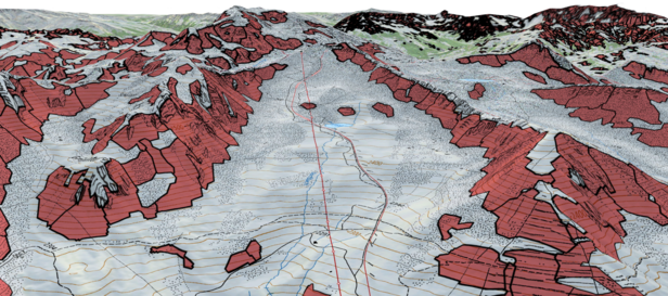
To calculate and visualize the potential avalanche hazard, researchers at the SLF have developed a method that automatically and efficiently pinpoints avalanche starting zones. They have now tested the procedure in three areas in the region of Davos. Based on these identified starting locations, the simulation software RAMMS can be used to model avalanches and their runout zones. The maps produced in this way highlight areas that could be endangered by avalanches, and are extremely useful in multiple applications, including the planning of new infrastructure.

In alpine regions it is especially important to know which areas are endangered by snow avalanches. In some countries, including Switzerland, hazard maps already exist. These have been produced on the basis of land registry information, climate data, terrain analyses and numerical simulations of avalanche dynamics. Hazard mapping by experienced specialists is, however, a costly and technically very sophisticated process. For this reason, it can be adopted only for individual avalanche paths, in particular those that pose a threat to settlements and key infrastructure.
Although indicative hazard maps are less detailed than regular hazard maps, they can provide an initial broad overview of natural hazards based on numerical simulations spanning large areas. This is especially useful for places which, as is the case in most of the world’s mountain regions, have only sparse records available regarding relevant events. Given that high-resolution digital elevation models, generated with the aid of modern remote sensing methods, are becoming available for more and more mountain regions as well, useful numerical avalanche simulations can now be performed for entire mountain ranges.
The ability to run dynamic avalanche simulations with the very latest software, such as RAMMS, depends on the precise identification of starting zones and fracture depths. The SLF has developed an algorithm to identify potential avalanche starting zones on the basis of terrain parameters. It was validated using a reference data set for three areas in the region of Davos. The automatic estimation of fracture depths is based on the increase in snow depth within three days, as measured by the SLF at numerous sites in the Swiss Alps for many years. This approach has already proven to be successful in Switzerland for regular hazard mapping purposes.

Once the starting zones have been identified and the corresponding fracture depths have been calculated, a simulation is performed for each of the relevant terrain polygons with the aid of friction parameters that have been validated in connection with regular hazard mapping. The procedure can be applied for a variety of scenarios, such as a return period of 5-30 years (frequent) or 100-300 years (extreme). This allows dynamic avalanche simulations to be performed efficiently and automatically not only for individual avalanche paths, but also in the context of large-scale applications at regional and national level. In several projects conducted with partners, including the canton of Grisons, the Alaska Division of Geological & Geophysical Surveys, and the Autonomous Province of Trento in Italy, we are applying this approach to produce large-scale indicative hazard maps, for example, that facilitate an assessment of the extent of protection afforded against snow avalanches by forests.
For the White Risk maps highlighting avalanche prone terrain, the researchers have simulated more than 860,000 typical skier-triggered avalanches. The simulations have been combined with terrain classification in a new product for backcountry tour planning. The automated procedure for plotting indicative hazard maps has also been used for individual regions of Uzbekistan and Afghanistan already, where there is at present a lack of information on avalanche danger. This is a very useful tool for those responsible for planning new infrastructure and evaluating existing defences for villages and roads.
