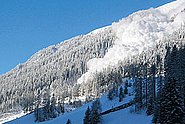
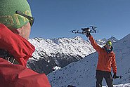
In the domain of avalanche road safety, local hazard experts have to assess the risk of an avalanche hitting the road given the predicted state of the snowpack and changing weather conditions. This project aims to present a proof of concept for a decision-support tool that facilitates risk assessment, provides a reproducible base for expert discussions and enhances the decision-making process by applying numerical models and providing probabilistic maps of avalanche run-out. These maps show the prediction of maximum avalanche impact for specific snow cover conditions. For this feasibility investigation, we consider one avalanche cycle from January 2019, in the Dischma Valley, located in Davos, Switzerland, where three cold avalanches got artificially triggered and reached the road. Photos of the powder cloud and meteorological data from stations nearby the avalanche tracks exist. Within one day after the avalanche events, drone-based photogrammetric measurements of the avalanche outlines and their mass balance, snow pit profiles at the top and bottom of the avalanche tracks were acquired. This unique dataset allows for a robust assessment of the avalanche modelling results. To represent different data availability cases, we investigate two options; a) a dataset in which the input data (new snow, snow temperature) are based on the weather station data collected nearby, and b) a data set derived from SNOWPACK simulation outputs, using weather data from a nearby station. We perform a set of RAMMS avalanche simulations with different values for the predicted average new snow height in the release zone and wind effects. By running multiple simulations for different input parameters, each assigned a specific probability that represents realistic snowcover conditions, we can produce probability-based avalanche run-out results that can be used for decision-making support. To assess the predictive power of the calculated maps, we compare modelled and observed avalanche core outlines.
Siehe Institutional Repository DORA