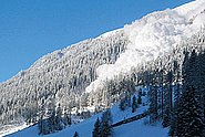
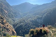
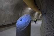
Forschungs-Schwerpunkte

  • Remote Sensing: Einsatz von Fernerkundung für die Schnee- und Lawinenforschung sowie alpine Naturgefahren
  • Drohnen: Unmanned Aerial Systems (UAS) im Hochgebirge
  • Grossflächige Kartierung von Lawinen
  • Räumlich zusammenhängende Schneehöhenkartierung mit digitaler Photogrammetrie
  • Grossflächige Gefahrenhinweiskarten: RAMMS::LSHIM
  • RAMMS: Rapid Mass Movement Simulation (Lawinen, Murgänge und Steinschlag)
  • Internationale wissenschaftliche Zusammenarbeit: SLF- Austausch mit Indien, Uzbekistan, Kirgizstan, Neuseeland, Türkei, Alaska ...
  • Mitglied Schweizerische Kommission für Fernerkundung SKF SCNAT

Ausbildung und Beruf

Projekte

In diesem Projekt entwickeln und kombinieren wir modernste Fernerkundungstechnologie mit Schneehöhenverteilung und RAMMS-Lawinenmodellierung. Damit wollen wir die Entscheidungsgrundlage für die Verkehrssicherheit im Dischmatal in Davos verbessern.

In this project, funded by the Swiss Agency for Development Cooperation (SDC / DEZA), we propose to apply large scale hazard indication mapping algorithms to the Himalayan province of Uttarakhand. Our goal is to identify unstable rock/ice masses and perform thermo-mechanical simulations - at the large-scale - to predict the danger of rock/ice avalanches, such as the recent event in Chamoli.

Fernerkundungsdaten - insbesondere die Optische- und Radarbilder - sind leistungsfähige Instrumente zur Überwachung von Hanginstabilitäten. In diesem Projekt untersuchen wir, wie diese Instrumente das Gefahrenmanagement auf regionaler Ebene unterstützen und unser Verständnis von alpinen Massenbewegungen verbessern können.

Flächendeckende und räumlich hochaufgelöste Satellitendaten, für kleinere Gebiete Drohnendaten, sind sehr gut zur Dokumentation von Lawinenperioden geeignet. Für eine zeitnahe Verwendung arbeitet das SLF an einer Automatisierung der Kartierung.

Das SLF hat eine Simulationssoftware für Steinschlag entwickelt. Mithilfe von Experimenten, wie kürzlich in Spitzbergen, lässt sich dieses Computermodell immer besser der Realität annähern.

Neuste Resultate zeigen: Mittels Drohnen lässt sich die Schneehöhe im Gebirge effizient und kostengünstig erfassen. Diese Technologie öffnet der Schneeforschung ganz neue Türen.

Flächendeckende Gefahrenhinweiskarten für Lawinen für Graubünden und Liechtenstein.

Rockfalls, debris flows and rockslides are gravitational mass movements that occur frequently in the mountains. Several SLF research groups are jointly developing methods to detect potential instabilities as early as possible.

Informationen über großräumig verteilte Schneehöhen basieren immer noch hauptsächlich auf interpolierten Punktmessungen. Neue Entwicklungen in der Sensor- und Softwaretechnologie für die digitale Photogrammetrie in den letzten zwei Jahrzehnten bieten neue Möglichkeiten, hochauflösende, digitale Oberflächenmodelle (DSM) auch über schneebedeckte hochalpine Regionen abzuleiten.

This project aims at improving the early detection of bark beetle damage in forests in the canton of Grisons as well as the prioritisation of management against bark beetle infestation in protective forests in the long term.

With this project proposal we aim at testing a procedure based on high spatial resolution SAR data in Uttarakhand. Our goal is to promptly follow surface changes leading towards potential catastrophic slope failure events.

Homogenous inventories of unstable alpine slopes by exploiting satellite radar interferometry.

The project aims at developing, testing and implementing machine learning routines applied to typical geological datasets to automatically identify structural feature traces and surfaces and differentiate discontinuity types.

Test of the suitability of the new SAR satellite ICEYE to monitor accelerations of surface motion at glaciers in critical conditions.

The project MODULATE aims at defining procedures useful for systematic displacement monitoring programs (and potentially early warning systems) involving radar imagery acquired from different sensors and platforms.

Publikationen

Dash R.K., Bartelt P., Zhuang Y., Bühler Y., Kanungo D.P. (2025) Recent rock avalanche event of July 10, 2024, near Patalganga Langsi Tunnel on the Badrinath Highway of Chamoli district, Uttarakhand, India. Landslides. 22, 255-260. doi:10.1007/s10346-024-02411-9 Institutional Repository DORA

Magnusson J., Bühler Y., Quéno L., Cluzet B., Mazzotti G., Webster C., … Jonas T. (2025) High-resolution hydrometeorological and snow data for the Dischma catchment in Switzerland. ESSD. 17(2), 703-717. doi:10.5194/essd-17-703-2025 Institutional Repository DORA

Ortner G., Michel A., Spieler M.B.A., Christen M., Bühler Y., Bründl M., Bresch D.N. (2025) A novel approach for bridging the gap between climate change scenarios and avalanche hazard indication mapping. Cold Reg. Sci. Technol. 230, 104355 (23 pp.). doi:10.1016/j.coldregions.2024.104355 Institutional Repository DORA

Ruttner P., Voordendag A., Hartmann T., Glaus J., Wieser A., Bühler Y. (2025) Monitoring snow depth variations in an avalanche release area using low-cost lidar and optical sensors. Nat. Hazards Earth Syst. Sci. 25(4), 1315-1330. doi:10.5194/nhess-25-1315-2025 Institutional Repository DORA

Sykes J., Haegeli P., Atkins R., Mair P., Bühler Y. (2025) Development of operational decision support tools for mechanized ski guiding using avalanche terrain modeling, GPS tracking, and machine learning. Nat. Hazards Earth Syst. Sci. 25(3), 1255-1292. doi:10.5194/nhess-25-1255-2025 Institutional Repository DORA

Bachmann O., Foubert A., Dèzes P., Hetényi G., Jäggi A., Müntener O., … Zeyen N. (2024) Geosciences community roadmap 2024. Update of Swiss community needs for research infrastructures 2029–2032. (Swiss Academies reports, Report No.: 19/8). Swiss Academy of Sciences (SCNAT). 36 p. doi:10.5281/zenodo.14264991 Institutional Repository DORA

Bartelt P., Stoffel L., Christen M., Bühler Y. (2024) Grain flow theory and snow avalanche rheology. In K. Gisnås, P. Gauer, H. Dahle, M. Eckerstorfer, A. Mannberg, & K. Müller (Eds.), Proceedings of the international Snow Science Workshop 2024. Oslo: Norwegian Geotechnical Institute. 360-365. Institutional Repository DORA

Bartelt P., McArdell B., Bühler Y., Graf C. (2024) Zweiphasenmodellierung von Murgängen für die Überprüfung von Schutzmassnahmen. In I. Schalko, D. Farshi, & A. Badoux (Eds.), WSL Berichte: Vol. 155. Fachtagung Wildbäche 2024: Modellierung von Wildbachprozessen. Birmensdorf: Eidg. Forschungsanstalt für Wald, Schnee und Landschaft WSL. 49-58. doi:10.55419/wsl:37776 Institutional Repository DORA

Bühler Y., Stoffel A., Liechti D. (2024) Where to put the weather station? Optimizing the location for automated snow depth measurements based on remote sensing, avalanche modeling and terrain characteristics. In K. Gisnås, P. Gauer, H. Dahle, M. Eckerstorfer, A. Mannberg, & K. Müller (Eds.), Proceedings of the international Snow Science Workshop 2024. Oslo: Norwegian Geotechnical Institute. 1054-1060. Institutional Repository DORA

Fergus Dal J., Hafner E.D., Peters T., Narnhofer D., Caye Daudt R., Heisig H., Bühler Y. (2024) Automated snow avalanche mapping with deep learning in aerial imagery from the extreme avalanche winter of 1999. In K. Gisnås, P. Gauer, H. Dahle, M. Eckerstorfer, A. Mannberg, & K. Müller (Eds.), Proceedings of the international Snow Science Workshop 2024. Oslo: Norwegian Geotechnical Institute. 1264-1271. Institutional Repository DORA

Glaus J., Wikstrom Jones K., Kleinn J., Stoffel L., Ruttner-Jansen P., Gaume J., Bühler Y. (2024) Probability-based avalanche run-out mapping for road safety. In K. Gisnås, P. Gauer, H. Dahle, M. Eckerstorfer, A. Mannberg, & K. Müller (Eds.), Proceedings of the international Snow Science Workshop 2024. Oslo: Norwegian Geotechnical Institute. 860-867. Institutional Repository DORA

Hafner E.D. (2024) Automated avalanche mapping with deep learning: from satellite to webcam imagery. [Doctoral dissertation] ETH Zurich. 139 p. Institutional Repository DORA

Hafner E.D., Kontogianni T., Daudt R.C., Oberson L., Wegner J.D., Schindler K., Bühler Y. (2024) Interactive snow avalanche segmentation from webcam imagery: results, potential, and limitations. Cryosphere. 18(8), 3807-3823. doi:10.5194/tc-18-3807-2024 Institutional Repository DORA

Hafner E.D., Techel F., Heisig H., Dal J.F., Bühler Y. (2024) Remotely sensed avalanche activity during three extreme avalanche periods in Switzerland. In K. Gisnås, P. Gauer, H. Dahle, M. Eckerstorfer, A. Mannberg, & K. Müller (Eds.), Proceedings of the international Snow Science Workshop 2024. Oslo: Norwegian Geotechnical Institute. 1222-1229. Institutional Repository DORA

Harvey S., Christen M., Bühler Y., Hänni C., Boos N., Bernegger B. (2024) Refined Swiss avalanche terrain mapping CATv2 / ATHv2. In K. Gisnås, P. Gauer, H. Dahle, M. Eckerstorfer, A. Mannberg, & K. Müller (Eds.), Proceedings of the international Snow Science Workshop 2024. Oslo: Norwegian Geotechnical Institute. 1637-1644. Institutional Repository DORA

Helbig N., Mott R., Bühler Y., Le Toumelin L., Lehning M. (2024) Snowfall deposition in mountainous terrain: a statistical downscaling scheme from high-resolution model data on simulated topographies. Front. Earth Sci. 11, 1308269 (19 pp.). doi:10.3389/feart.2023.1308269 Institutional Repository DORA

Kleinn J., Bühler Y., Glaus J., Aller D., Berger C., Rinderer M., … Singeisen C. (2024) A probability-based modelling approach beyond a few selected return periods for comprehensive and robust hazard and risk assessment. In K. Gisnås, P. Gauer, H. Dahle, M. Eckerstorfer, A. Mannberg, & K. Müller (Eds.), Proceedings of the international Snow Science Workshop 2024. Oslo: Norwegian Geotechnical Institute. 841-847. Institutional Repository DORA

Kyburz M.L., Sovilla B., Bühler Y., Gaume J. (2024) Potential and challenges of depth-resolved three-dimensional MPM simulations: a case study of the 2019 "salezer" snow avalanche in Davos. Ann. Glaciol. 65, e19 (14 pp.). doi:10.1017/aog.2024.14 Institutional Repository DORA

Manconi A., Bühler Y., Stoffel A., Gaume J., Zhang Q., Tolpekin V. (2024) Brief communication: monitoring impending slope failure with very high-resolution spaceborne synthetic aperture radar. Nat. Hazards Earth Syst. Sci. 24(11), 3833-3839. doi:10.5194/nhess-24-3833-2024 Institutional Repository DORA

Munch J., Bühler Y., Zhuang Y., Manconi A., Bartelt P. (2024) Understanding flow transitions in multi-component avalanches. In J. Schneider (Ed.), Interpraevent 2024. Conference proceedings. Klagenfurt: Interpraevent. 138-143. Institutional Repository DORA

Alle anzeigen
×